Export 3D Panorama
|
|
To export the Heron® measurable spherical images with xyz coordinates in the image background. Both streaming (acquired in continuous) and single-shot panoramic images are supported. The process generates a structured point cloud at the resolution of the panoramic image in correspondence of each selected panoramic images. The so called “3D Panorama” can directly exported as E57 or in Autodesk ReCap®, and saved as Grids inside Reconstructor®. |

![]() This functionality allows to generate and export RGB point clouds when using Heron LITE Color.
This functionality allows to generate and export RGB point clouds when using Heron LITE Color.
Select the Export 3D Panorama command in the Heron top toolbar; a Recently used item dialog allows to select the Heron® Survey you want to export from the proposed list.
In the next dialog you have different options.
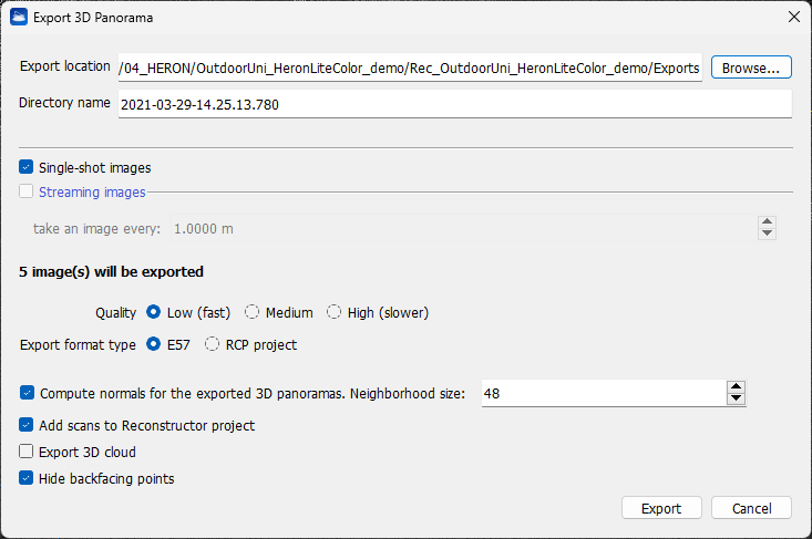
- Enter a Directory name defining an output sub-folder that will be saved in the folder defined in the Export location.
- Flag Single-shot images if single-shot high resolution images are captured during the survey and you want to use them to also export panoramic views (cameras) in high resolution. You can also use these cameras to extract and colorize structured point clouds hereafter referred to as "scans") at each panoramic view.
- In the same way, flag Streaming images to use the video streaming to extract panoramic views every X meters along the trajectory and create colored structured clouds.
 This option is available only for data from HERON® MS Twin, AC-2 and HERON® LITE Color series.
After selecting the option, the number of used cameras and 3D Panoramas is reported.
Point Density options
- The density of the extracted point cloud(s) can be defined by selecting Low / Medium / High Quality settings. The higher the quality, the slower the export process but the denser (with gap filling) the final point cloud in the background of spherical image.
- low: the point cloud in the background of the spherical image has the density of the original Heron point cloud
- medium: the point cloud in the background of the spherical image has the density of the Heron point cloud rendered with the splat rendering option
- high: the point cloud in the background of the spherical image has the density of the Heron point cloud rendered with the splat rendering option and with an additional depth filling.
Export options
- The colored point clouds can be exported as .e57 structured point clouds associated with 3D panoramas at full resolution (as applicable); they can thus be available in third party software.
- Alternatively, the colored point clouds can be exported in a .rcp ReCap® project with relative 3D panoramas at full resolution (as applicable), visible in RealView.
Advanced options
- Flag the option Compute normals for the exported 3D panoramas to improve the resulting structured point clouds' normals computation and their orientation, accordingly.
- Flag the option Add scans to Reconstructor project if you want to add to your Reconstructor® project the .rgp structured scans created in correspondences of any 3D panorama.
- Flag the option Export 3D cloud if you want to export also the original 3D point cloud beside single 3D Panoramas.
- Flag the option Hide backfacing points if you want to hide the points that are oriented in the opposite direction to the pano's point of view. The orientation is calculated according to the point normal. The surfaces scanned from a point opposite to the current point of view will be hidden.
![]() If a HERON survey includes static scans, only the Heron clouds with associated trajectories are exported.
If a HERON survey includes static scans, only the Heron clouds with associated trajectories are exported.
Click the Export button to start the export process. At the end of the process a pop up window allows to open the folder where export is saved.