Heron share
|
|
A Heron® Survey can be exported in customized formats to be loaded in several platforms. |

According to the specification of the software/platforms, different information can be supported: a single merged point cloud including 3D panoramas and their position respect to the point cloud's reference system, but also single point clouds, with or without 3D panoramas .
The several exporting possibilities are below explained, as well as the steps to follow to complete the procedures.
|
|
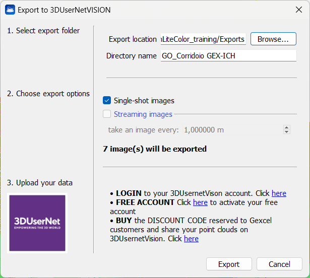
It is a branded portal to store and view all your survey data, for Inspection and Monitoring, Design, Planning, and Asset Management.
|
|
|
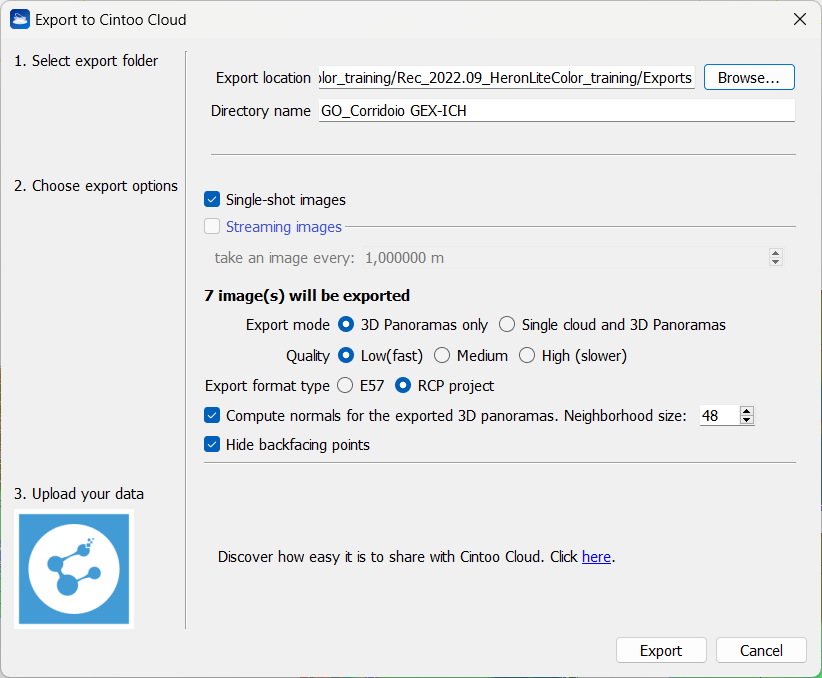
Cintoo Cloud (*) It is a cloud-based Reality Data management and collaboration platform. By transforming large point cloud data into meshes, the data is shareable, collaborative, and distributable with clients, contractors and your own teams.
By this dialog you can set the structure and the quality of the data to be exported, as well as the export format: E57 or ReCap project. Once in Cintoo, have a look at the Cintoo Cloud User Guide to learn how to upload a Gexcel Heron data by importing this just exported object as structured scan. |
|
|
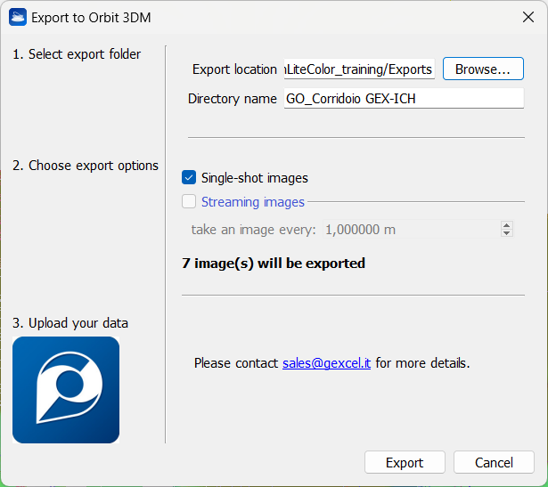
Orbit 3DM (Bentley) It is a cloud-based solution for publishing and sharing mapping data.
|
|
|
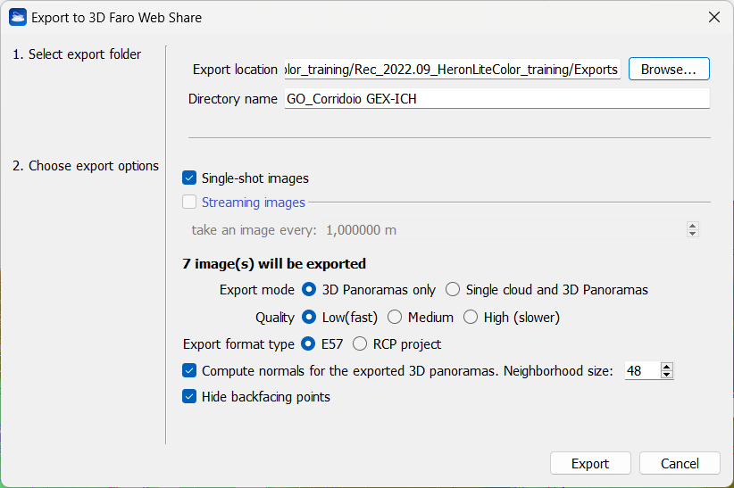
FARO WebShare (*) It is a cloud-based hosting platform, offering real-time access to the latest reality data for worldwide project management and BIM workflows.
|
|
|
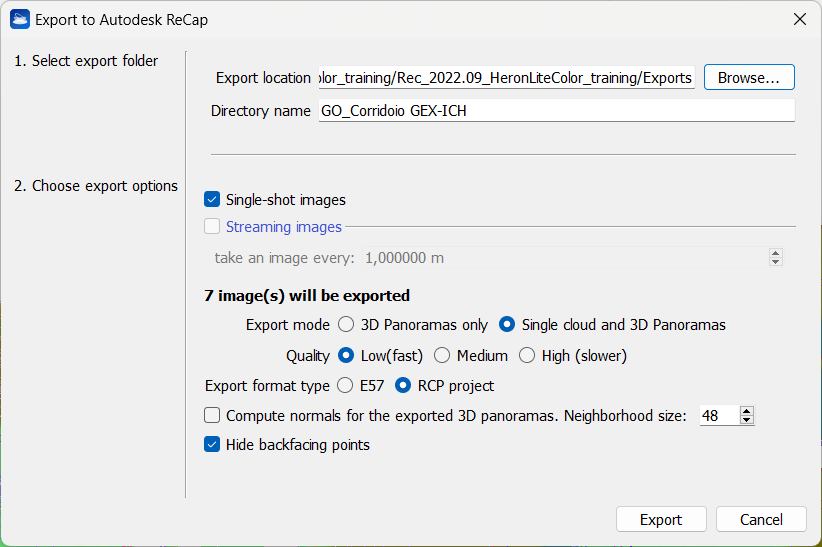
Autodesk ReCap (*) It is the Autodesk® reality capture and 3D scanning software for intelligent model creation. A ReCap project (.rcp) will be directly created by using this tool. See more details at Export to Autodesk ReCap page. |
|
|
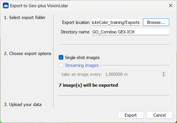
Geo-Plus VisionLidar It processes point clouds and 3D images of aerial, terrestrial and mobile LiDAR data.
|


Main steps
Three easy and customized steps are proposed when accessing the different commands to export the HERON® data from Reconstructor® and to import them in the previous exposed software/platform.
1. Select export folder
Browse the output folder and choose a directory name.
2. Choose export options
- Flag Single-shot images if single-shot high resolution images are captured during the survey and you want to use them to also export panoramic views (cameras) in high resolution. You can also use these cameras to extract and colorize structured point clouds hereafter referred to as "scans") at each panoramic view.
- In the same way, flag Streaming images to use panoramas acquired in continuous to extract a discrete number of panoramic views (setting their distance along the trajectory with "take an image every: ...") and create colored structured clouds.
(*) In the case of Cintoo Cloud beta version, 3D Faro Web Share and Autodesk ReCap, it is also possible to choose to export not only a merged point cloud including the different 3D panoramas, but also single clouds centered on each image and the relative 3D panoramas (within their position in the reference system).
After choosing if you want to export:
- 3D Panoramas only
- Single clouds and relative 3D panoramas
you can define the density of the extracted point cloud(s) by selecting Low / Medium / High Quality settings. The higher the quality, the slower the export process but the denser (with gap filling) the final point cloud in the background of spherical image.
- Low (fast): the point cloud in the background of the spherical image has the density of the original Heron point cloud
- Medium: the point cloud in the background of the spherical image has the density of the Heron point cloud rendered with the splat rendering option
- High (slower): the point cloud in the background of the spherical image has the density of the Heron point cloud rendered with the splat rendering option and with an additional depth filling.
- Flag Compute normals for the exported 3D panoramas to recompute the normals in the point clouds, according to the panorama's center of view.
- Flag Hide backfacing points to activate the homonym option (see Display and navigation Options).
![]() All the processes involve the export of the point clouds with the relative panoramic cameras (which must therefore be present in the Heron Survey), with the exception of 3DUserNet for which it is possible to export only the clouds (even without having the images).
All the processes involve the export of the point clouds with the relative panoramic cameras (which must therefore be present in the Heron Survey), with the exception of 3DUserNet for which it is possible to export only the clouds (even without having the images).
3. Upload your data in the software/platform
The data, as it is exported, can be then loaded in the required platform.
![]() The info about the process to follow to import data in the previous platforms are available in the dedicated pages in our Gexcel website and in the next notes:
The info about the process to follow to import data in the previous platforms are available in the dedicated pages in our Gexcel website and in the next notes:
- Click here to learn how to import the HERON data in 3DUserNet.
- Click here to learn how to import the HERON data in Cintoo Cloud.
- To Import the data in FARO WebShare you before need to load the exported data in FARO Scene.
See at the FARO WebShare Cloud knowledge page for more details.
In case of further need please contact us at support.heron@gexcel.it.