Georeferencing
|
|
The LineUp® toolbox includes a procedure to geo-reference the imported point clouds, through reference points |

|
|
|
|
|
To georeference any items or entire projects using two point lists |


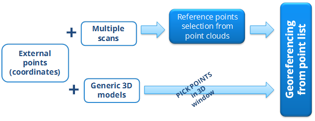
This process allows you to georeference multiple scans using both targets (or other points) and the centers of the scans (if geo-referred).
You can georeference one or more scans by selecting at least 3 points from different scans, known also in another reference system (for example from topography). In the same way a georeferentiation of generic 3D models (i.e mesh models from BIM) is possible (see 3D Model georeferencing).
These steps will be illustrated in the following:
To find and manage reference points on the point clouds in the project, you can use the commands:
|
|
To manually pick points on a generic object in the point cloud and to manage them |
|
|
To automatically find the center of planar circular target or manually pick points on a generic object in the point cloud |
|
|
To automatically find the sphere center |