Create UCS from point list
|
|
The command is available in the Data Management > LineUp Top menu. |
It creates a new UCS from two sets of points. Switching to the resulting UCS will show the points of the first set with the coordinates of the second set.
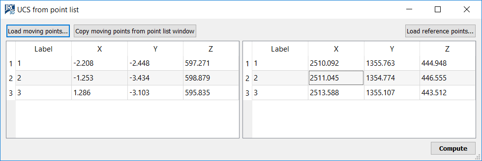
Given two lists of points, this function creates a new UCS such that the points having coordinates in list 1 will assume the coordinates in list 2 after switching to the resulting UCS, except from a controllable mean-squared error.
Press the buttons Load moving points on top left to load a text file with the first point list, and Load reference points on top right to load a text file with the “reference” coordinates of the points, the coordinates that are going to be shown in the new UCS. To parse the text files with the point list, an appropriate tool is used. You can use as moving points the points listed in the point list window, via the appropriate button on top left.
After loading the first and the second list of points, press Compute on the bottom right. A dialog appears, asking whether you want to register the points by coupling them according to their labels, or by trying out all the possible pair combinations to find the best. The first option is much faster but it assumes that you are sure about how to match your points. After you have selected either Match names or Best fit, you can refine and make use of the results of the registration, in the dialog shown below.
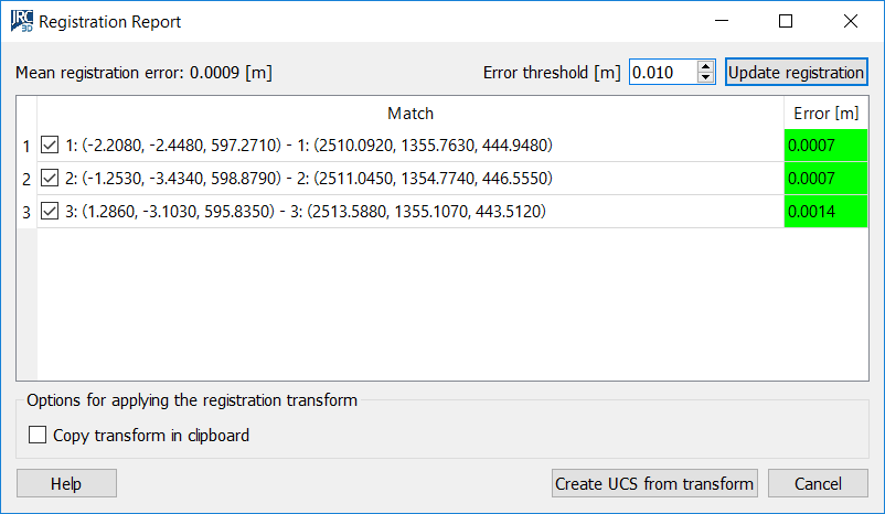
In the dialog above, it is possible to set the error threshold and to exclude outliers in order to improve the mean registration error. The way to do that is described in ICP Registration. Once you have refined the mean-squared error (shown on top left), press Create UCS from transform to create the desired UCS. The resulting UCS will be inserted in the project window.
This procedure uses the same calculations as georeferencing from point list.
Create UCS from point list registration: starts a procedure to create a coordinate system that is based on the algorithm of the former procedure. It exploits the same concept of registering the listed points against another point list that is considered as reference. However, the final result does not consist in moving all the project items, but in creating a new UCS and to place it so that all the other entities appear as if they were moved according to the found registration. For example, if the registration implies a translation of (1000, 1000, 1000), then a new UCS is created placed (-1000, -1000, -1000) away from the current one. Then, this new UCS is set as current. One benefit of this procedure is that you can easily undo its effects, by simply setting the former UCS back as current. The drawback is that ambiguities may rise if you work with other users that do not use the same UCS and assume that you have geo-referenced the data, or ambiguities may rise if you import Reconstructor models saved in earlier projects that were geo-referenced in the other way.