Cloud-to-cloud (and mesh) registration
The LineUp® tool includes a comprehensive suite of tools for coarse and fine registration of any amount of scans (and not only). The registration process is composed by several steps, depending on adopted survey techniques.
The general flow, here illustrated
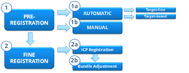
starts from a preregistration step that allows you to compute a rough alignment between the imported models. The alignment can be later refined using ICP registration and Bundle Adjustment to choose and refine the good ICPs and discard the wrong ones, in order to reduce the global registration error.
See Getting Started -> Register to learn how to use the The LineUp® registration tools.
See Getting Started -> Georeference to learn how to use the the LineUp® georeferentiation tool.
Registration
- Automatic, target-free preregistration
- Automatic, target-based registration
- Manual pre-registration
- ICP registration
- Bundle Adjustment
- Scan alignment per groups
Georeferencing
Positioning